Discover an unparalleled mapping experience with over 100 types of maps at your fingertips, including those from the esteemed Geographical Survey Institute. Whether you're scaling mountains or strolling through urban landscapes, these maps will enhance your adventures by maximizing the use of elevation differences.
Proudly recognized with the 2018 Japan Cartographic Society Award for Best Work, our app leverages unique technology to provide "super terrain data," accentuating the terrain for an immersive experience. You can explore a vast array of maps, from the Geospatial Information Authority of Japan's offerings to topographic, geological, historical, and even prewar Ordnance Survey Department maps. Utilize your device's GPS to record tracks and manage your trajectories with GPX log input/output and editing capabilities.
Our app is fully equipped to support your urban explorations, mountain climbs, and outdoor activities with features like GPS navigation with audio cues, data recording, and editing. The visibility determination function aids in creating cross-sectional diagrams, enhancing your observation and communication capabilities, while also allowing for the display of buildings.
Experience breathtaking 360° panoramic views and identify mountains effortlessly. You can track the positions of the sun, moon, and GPS points, making it an ideal tool for capturing moments like Diamond Fuji or Pearl Fuji. With offline capabilities, including bulk map downloads and map caching, your adventures won't be hindered by a lack of radio signals.
Enrich your journey by associating photos with specific points, viewing contour lines derived from elevation data, and displaying the MGRS grid. You can also read, display, and edit GIS data from GeoJSON files, draw shapes, and use the app overseas. The functionality extends to map printing and PDF output, with a dark theme available for enhanced viewing.
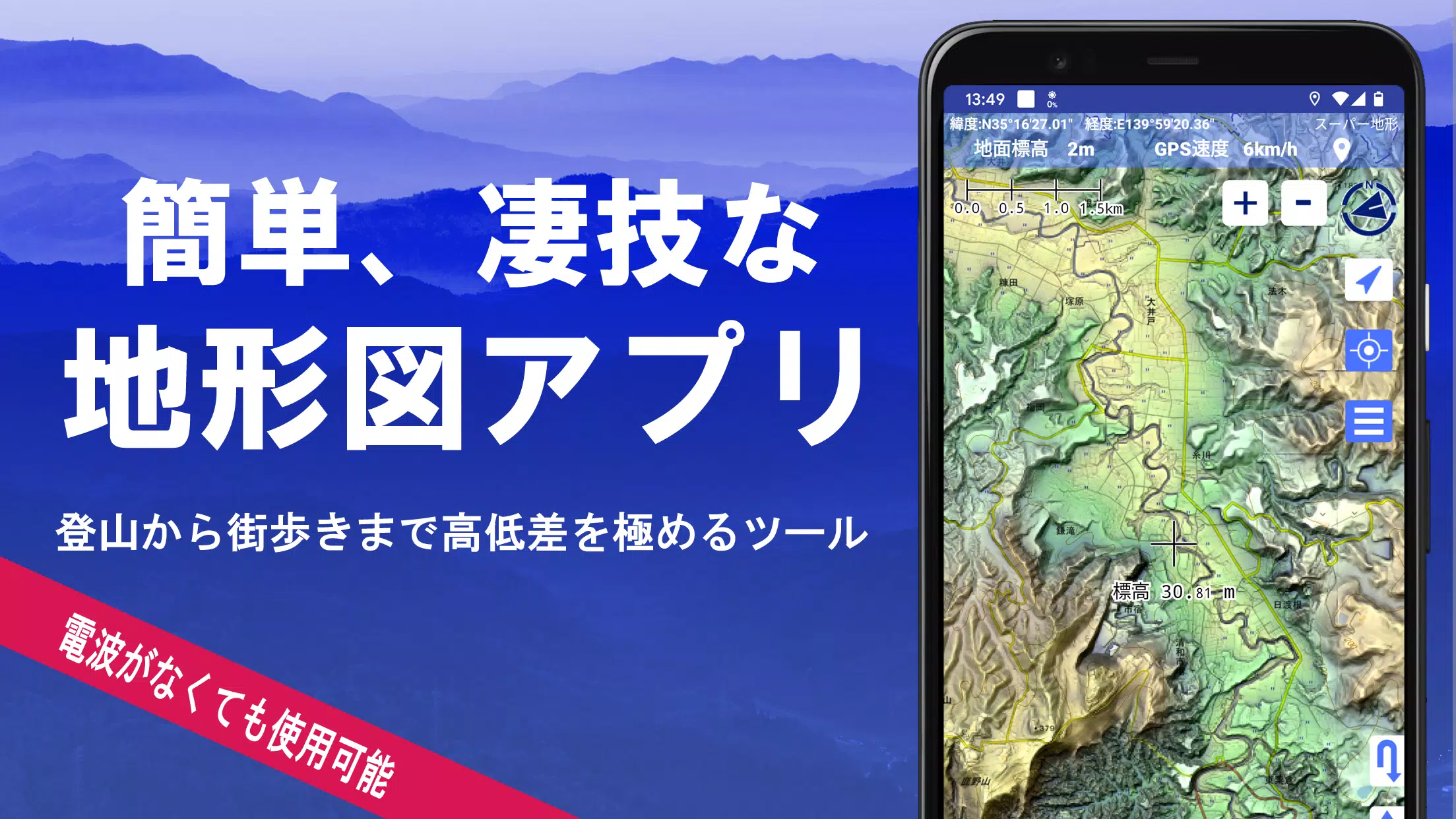
A Wealth of Maps at Your Disposal
Our collection includes over 100 types of maps, from our proprietary super topographic data to maps provided by the Geospatial Information Authority of Japan and hazard maps. Note that aerial photographs may vary by age group, with the "latest" and "around 1974" having wider coverage areas. Enjoy a 5-day free trial of the super terrain data map upon installing the app.
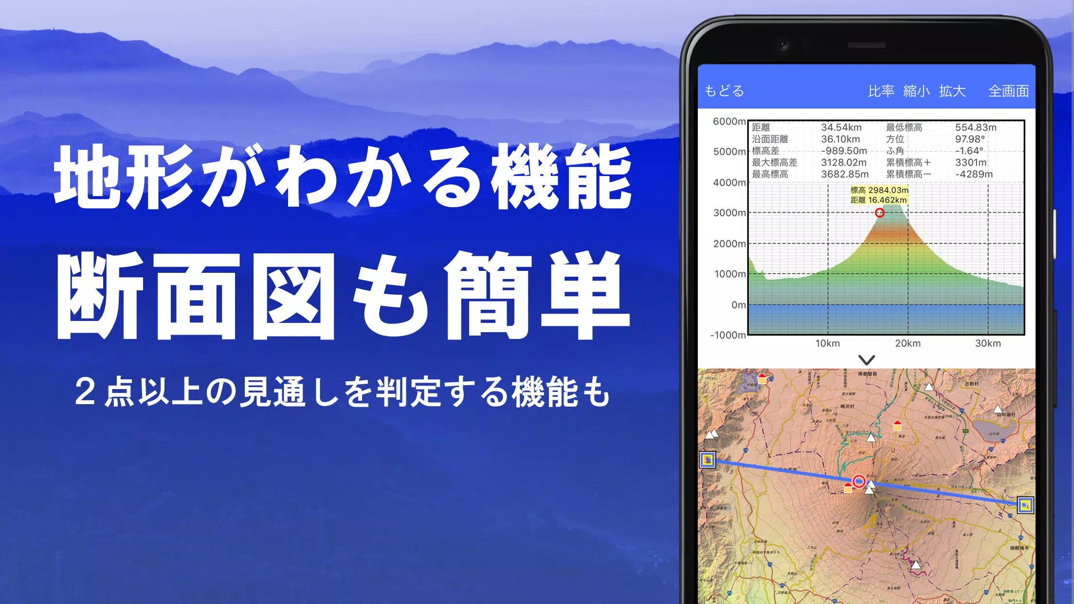
Cross Sections and Outlook Creation
Effortlessly draw cross-sections through any point on the map. Our app includes a visibility judgment function, considering the Earth's curvature and atmospheric conditions, making it perfect for route planning during climbs, assessing wireless visibility, and understanding terrain. Where available, PLATEAU building data can be incorporated into your cross-sectional views.
Elevation Palette Function
Customize your map's background color with the elevation palette function, adjusting it in 1cm increments to your preferred gradation.
Panoramic Views
From any location, view panoramic observation maps that reveal mountain names. Enjoy a 360-degree panorama linked to your smartphone's compass, perfect for mountain identification. Track the sun and moon's positions, including moon phases, and explore phenomena like Diamond Fuji and Pearl Fuji. You can also view GPS points and create panoramic views of overseas mountains.
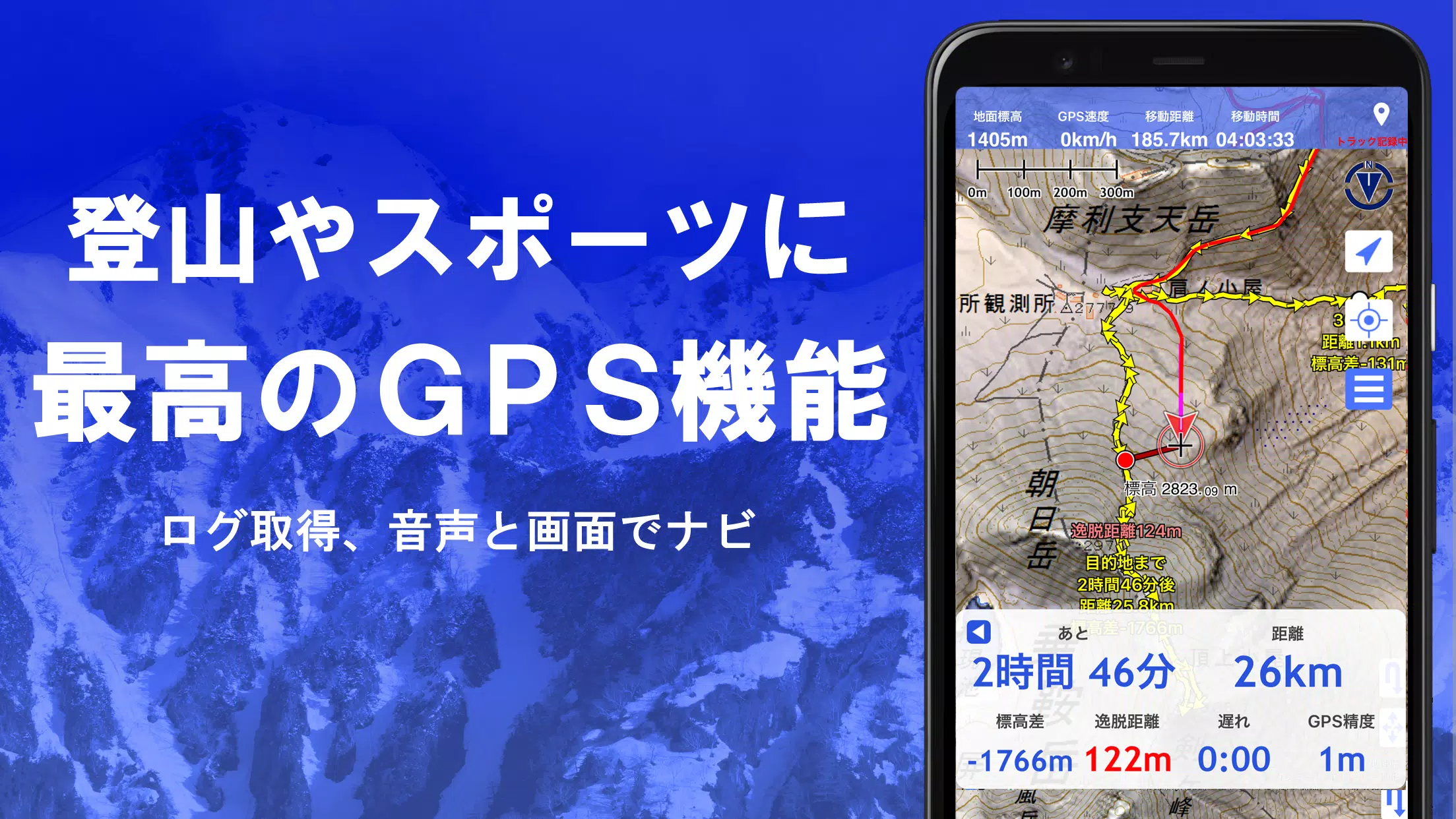
GPS Functionality
Harness your smartphone's GPS to obtain precise location information and record tracks. Our high-precision position measurement is designed for rigorous mountain climbing and outdoor activities. Visualize your tracks with graphical displays showing elevation changes, speed, time, and elapsed time. Receive voice and alarm notifications as you approach designated points, and display photos linked to specific locations. You can also send the map center position to NaviCon.
GPS Track Summary Playback
Replay your recorded tracks comprehensively. The app matches and automatically displays photos based on their shooting times, with icons indicating photo locations that can be viewed with a tap.
GPS Navigation Function
Navigate along preset tracks using the Track Navi feature, receiving voice or alarm alerts if you deviate. This ensures you won't get lost during your climbs. Additionally, utilize route navigation for urban walks and point navigation to reach specific locations.
GPS Data Editing Function
Manage points, routes, and track data with ease, organizing them into folders displayed in an easy-to-read tree format. Create tracks directly on the map, and import or export data in GPX format from mountain climbing sites.
Offline Map Usage
Continue your adventures in areas without signals, thanks to our bulk download function, which ensures you have all necessary scale maps for your specified area. A cache function is also available, allowing you to see what's downloaded and preventing map shortages on-site.
Map History Function
The app remembers previously viewed locations, enabling you to return to them effortlessly.
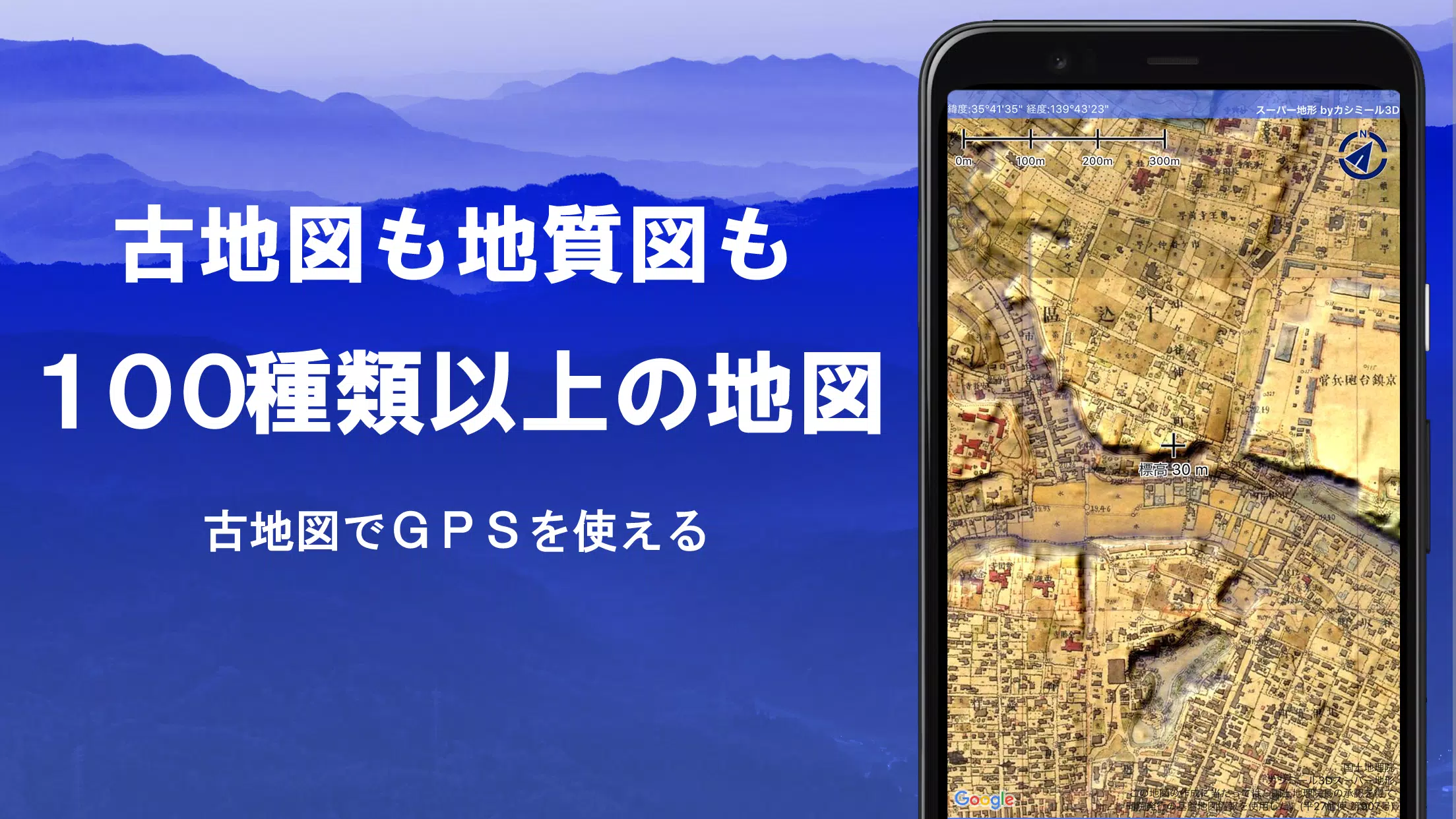
Custom Map Compatibility
Import and utilize custom maps crafted with Kashmir 3D's map cutter. Display your personal or scanned maps by dividing images into approximately 256 x 256 sections and sending the resulting kmz file to Super Terrain via email or Cloud Drive.
GeoJSON Compatibility
Work with GeoJSON format files to display and edit points, linestrings, and polygons, and create new shapes.
Print/PDF Output
Print any map area at a specified scale or generate a PDF for your records.
Integration with Other Apps
Input and output GPS data in GPX, KML, and GDB formats, allowing data exchange with other apps, Kashmir 3D on your PC, and trajectory data from mountain climbing sites.
Backup Function
Back up all app data (excluding cached maps) and remove it from your smartphone. Restore your data even if you delete the app or encounter device issues. An automatic backup feature using Google Drive ensures your data remains up-to-date. Refer to the manual for detailed instructions.
Billing Function
Certain features like maps using super terrain data, GPS track functions, and cross-sectional views are available through in-app purchases. After payment, you'll enjoy an increased number of search results for place names. The annual fee is 780 yen/year, with a 5-day free trial upon first installation. To purchase, navigate to [Settings] - [Purchase to remove functional restrictions] within the app. You can check or cancel automatic updates through Google Play under "Regular Purchase" and selecting "Super Terrain." Prices may be revised with future enhancements, so early purchase is advantageous.
Terms of Use
The copyright holder and developer are not responsible for the outcomes of using this app. Upon first using GPS, you'll be prompted to allow location services. Continuous GPS use may drain your battery, so if your device is needed for emergency communication, carry a spare battery. For detailed navigation guidance, refer to the provided PDF at https://www.kashmir3d.com/online/superdemapp/superdem_navi.pdf. Note that some smartphones may interrupt or fail to record tracks due to power-saving features; temporarily turning off the screen may help, but this is not a permanent solution.
Tags : Maps & Navigation